(Psalms 103:5) (Is The Earth is Not a Globe or is The Earth a Globe?)
- Thread starter Conformed
- Start date
-
Christian Chat is a moderated online Christian community allowing Christians around the world to fellowship with each other in real time chat via webcam, voice, and text, with the Christian Chat app. You can also start or participate in a Bible-based discussion here in the Christian Chat Forums, where members can also share with each other their own videos, pictures, or favorite Christian music.
If you are a Christian and need encouragement and fellowship, we're here for you! If you are not a Christian but interested in knowing more about Jesus our Lord, you're also welcome! Want to know what the Bible says, and how you can apply it to your life? Join us!
To make new Christian friends now around the world, click here to join Christian Chat.
More dumb memes. This guy just doesn't get it.
Sometimes I wonder what they're true intentions are. It just seems like they're just pretending to be one of us but mocking the Bible by taking it's verses the wrong way to show the rest of the world how the Bible shouldn't be believed or trusted.
I'm just glad I had not come across any of them before the Lord saved me. I might not have wanted to trust the Bible as coming from the Lord.
💮
-
3
- Show all
So...you started a thread for people to NOT engage on?
What keeps an airplane from flying to the backside of a relatively flat earth?
What keeps an airplane from flying to the backside of a relatively flat earth?
To do that, the airplane would have to fly south. No airplane ever crosses over the South pole in Antarctica to make a shortcut to its destination. I think there was alleged to be one once, but it was a claim with very little (no?) evidence. If the Earth were a ball, planes should be short-cutting over Antarctica (i.e. the South pole) all the time. They're certainly not.
-
1
- Show all
No. It's very difficult to map. The best I can do is poke holes in ball-Earth maps, but their defense is the same as mine "It's very difficult to map".
-
2
- Show all
This presents problems for any view. I would think a flat earth would be relatively easy to navigate and map in our time. What hinders this?
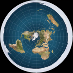
Given Antarctica is on the edge of our Flat Earth, I'm sure you can appreciate how difficult this makes mapping for Flat Earthers.
The below is an approximation I found on the internet, but it's not as accurate as Flat Earthers would like, given the aforementioned conspiracy by the governments of the world.

-
1
- Show all
The governments of the world don't like people to explore Antarctica. Without a licence etc., as having to obtain a licence means the governments have foreknowledge of the expedition, and can therefore much more readily thwart or control it.
Given Antarctica is on the edge of our Flat Earth, I'm sure you can appreciate how difficult this makes mapping for Flat Earthers.
Given Antarctica is on the edge of our Flat Earth, I'm sure you can appreciate how difficult this makes mapping for Flat Earthers.
-
1
- Show all
Sure, but I don't believe exploration of the South Pole or lack of it hinders mapping the rest. Surely the rest can be mapped.
If the earth is flat, there has to be a point where one can go no farther. Why haven't we found this point?
Yes. We have reasonable approximations of the shapes of the countries etc., but not the best understanding of positioning in relation to the edges. There are never-ending debates around flights between Australia and South Africa and South America, for example. A proper understanding of Antarctica (the edge), in my view, would allow more precise positioning and reduce such arguments.
We have. Look at the map. It's the South "pole". Not actually a pole, but we can't go further South. Actually, we can, but it's not recorded on any maps. That's why the governments maintain a monopoly on access to Antarctica. They don't want people to know the truth.
We have. Look at the map. It's the South "pole". Not actually a pole, but we can't go further South. Actually, we can, but it's not recorded on any maps. That's why the governments maintain a monopoly on access to Antarctica. They don't want people to know the truth.
What I'm getting at is, if a plane starts flying due west along the equator, what happens?
-
1
- Show all
No. It's very difficult to map. The best I can do is poke holes in ball-Earth maps, but the defense of the makers of such maps is the same as mine - "It's very difficult to map".
-
1
-
1
- Show all


